
Niagara Peninsula

![]() Niagara Fall is relatively close to where I live so there's a tendency to take its majesty for granted. I visted the Niagara peninsula often many years ago but hadn't recently so decided it was time for a return visit, this time with a camera.
Niagara Fall is relatively close to where I live so there's a tendency to take its majesty for granted. I visted the Niagara peninsula often many years ago but hadn't recently so decided it was time for a return visit, this time with a camera.
The spectacular Falls and the scenic Niagara River Gorge are the obvious attractions, but there's much more. The regional parks system features jewels all the way from Niagara-on-the-Lake in the north to Fort Erie in the south.
And there are some unique industries. The Welland Canal provides a bypass of the Falls for the huge Great Lakes freighters. Niagara's hydro-electirc power plants produce a quarter of the electricity for Ontario and New York State. And the region's mild microclimate has hosted the development of a vibrant wine industry.
Recent "America First" threats and aggressions have an unfortunately familiar ring here. Reminders of America's failed attempt at annexation during the War of 1812 still cover the peninsula.
The link to the Pictures File is below the Sample Images.
Note: Even if you've visited this site often in the past please check out the new Viewing Setup Hints page to ensure that your browser controls display the PDFs as intended.
Quick Start: Niagara-Peninsula.pdf
Top Sample Images Links to Pictures Files Map Contents Bottom
Sample Images
Here are a few sample images from the picture files. You can click or tap on these to see larger versions.

Horseshoe Falls

American Falls

Hornblower Cruise

Dufferin Islands

Niagara-on-the-Lake

Peller Estates Winery

Brock Monument

Falls Illumination
Top Sample Images Links to Pictures Files Map Contents Bottom
Links to Files
You can access the PDF pictures file by clicking or tapping on the link below.
| File | Pages | Size |
|---|---|---|
| Niagara-Peninsula.pdf | 98 | 16.8 MB |
Top Sample Images Links to Pictures Files Map Contents Bottom
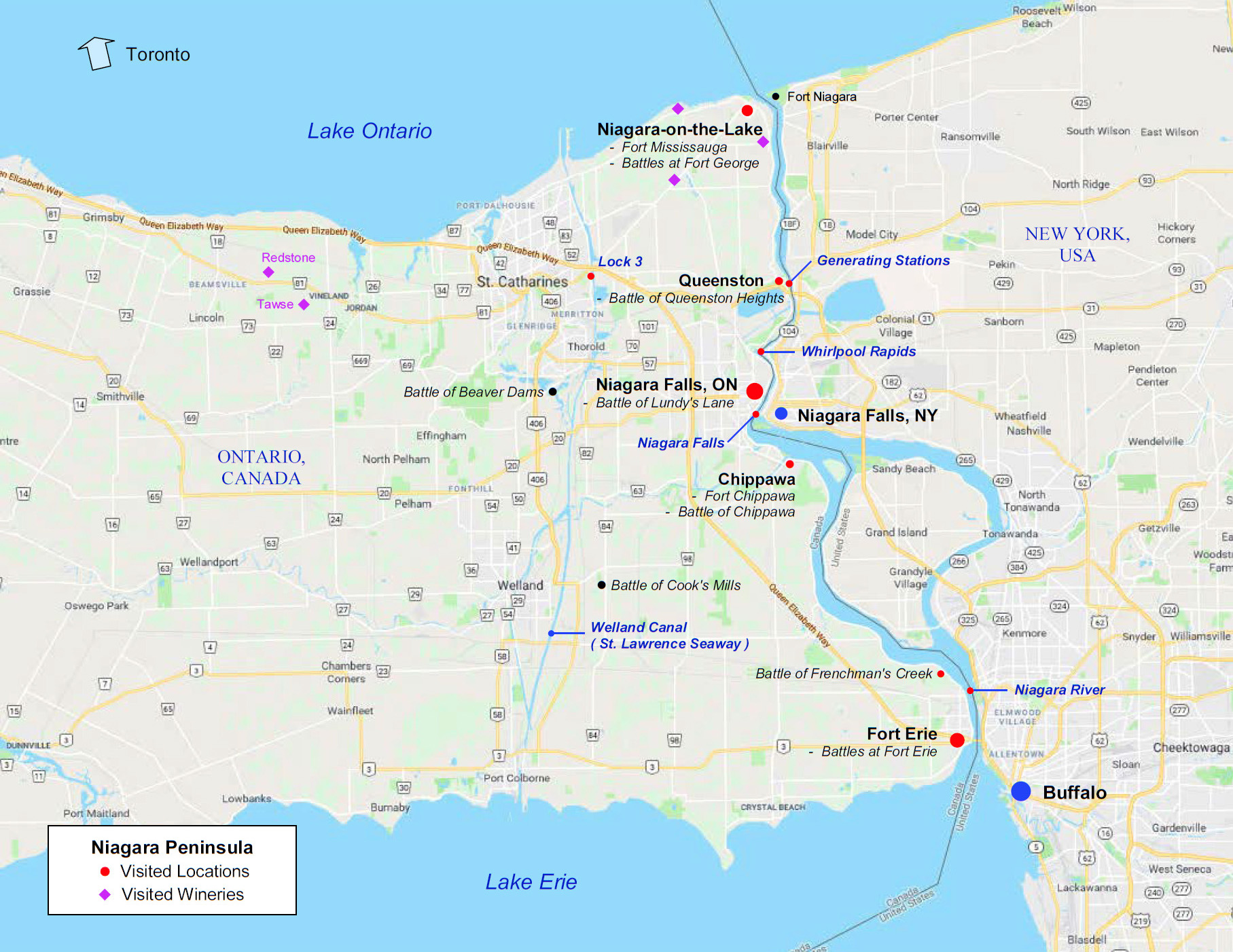
Map
The overview map below and a map of the central section of the Niagara River are included in the pictures PDF.
The overview map is included in a package of printable Ontario Maps if you wish a paper copy to follow along.
Top Sample Images Links to Pictures Files Map Contents Bottom
Table of Contents
The Contents table for this PDF is reproduced below. The combined Contents tables for all Ontario pictures files are included in the printable Ontario Contents PDF.
| Niagara-Peninsula.pdf | |
| Contents | 2 |
| Introduction | 3 |
| Map | 4 |
| Niagara Falls | |
| Welcome | 5 |
| The Falls | 6 |
| Hornblower Cruise | 13 |
| Journey Behind The Falls | 20 |
| Niagara Parks Commission | 24 |
| Oakes Garden Theatre | 27 |
| Clifton Hill | 30 |
| Niagara-on-the-Lake | 32 |
| The Niagara Parkway | 36 |
| Floral Showhouse | 38 |
| Dufferin Islands | 42 |
| Botanical Gardens | 45 |
| Butterfly Conservatory | 47 |
| Floral Clock | 48 |
| Whirlpool Rapids | 49 |
| Navigation | |
| The Welland Canal | 51 |
| Welland Canals Centre | 54 |
| Hydro-Electric Power | 55 |
| Nikola Tesla | 56 |
| Early Hydro | 58 |
| Hydro Today | 61 |
| Niagara Wineries | 63 |
| The War of 1812 | 69 |
| The Niagara Frontier | 70 |
| 1812 Queenston Heights | 71 |
| Frenchman's Creek | 74 |
| 1813 Fort George | 75 |
| Beaver Dams | 81 |
| Fort Niagara | 83 |
| 1814 Fort Erie | 84 |
| Chippawa | 87 |
| Lundy's Lane | 88 |
| Conclusion | 92 |
| Night Lights | 93 |
Top Sample Images Links to Pictures Files Map Contents Bottom